Roadmap Penelitian 2026-2028
AI-Coastal Risk System
Sistem Prediksi Risiko Erosi Pesisir Berbasis Kecerdasan Buatan dan Simulasi Monte Carlo
Kerangka Pikir Riset
Kerangka pikir penelitian ini menggambarkan alur sistematis dari pengumpulan data hingga pengembangan produk akhir AI-Coastal Risk System. Pendekatan yang digunakan mengintegrasikan multiple data sources, advanced analytics, dan machine learning untuk menghasilkan sistem prediksi yang robust dan probabilistik.
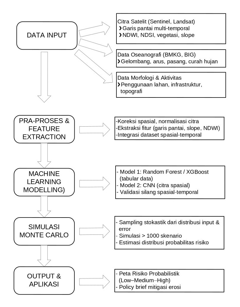
Gambar: Kerangka Pikir Riset
Tahapan Penelitian Keseluruhan
Tujuan Utama:
Tahapan kegiatan disusun untuk memastikan tercapainya
akhir AI-Coastal Risk System secara bertahap
selama 3 tahun, sesuai dengan peta jalan penelitian.
| Tahun | Fokus Tahapan | Komponen Utama | Luaran Antara |
|---|---|---|---|
|
2026 (Tahun 1) |
Data Foundation and Feature Extraction |
|
Dataset spasial-temporal lengkap + baseline mapping erosi |
|
2027 (Tahun 2) |
Model Development and Stochastic Simulation |
|
Model AI-Monte Carlo terverifikasi |
|
2028 (Tahun 3) |
Integration, Dissemination, and Innovation Product |
|
Produk akhir + policy guidebook |
Metodologi Tahun Pertama (2026)
Tahun pertama merupakan tahap dasar (foundational phase) yang berfokus pada pembentukan database spasial-temporal risiko erosi dan pra-pemrosesan citra satelit sebagai bahan utama untuk pelatihan model ML di tahun berikutnya.
1. Pengumpulan dan Integrasi Data
Tahapan Pengumpulan Data:
- Akuisisi citra multi-temporal 2015-2026
- Koreksi atmosferik dan geometrik citra
- Penyesuaian sistem koordinat dan overlay
- Integrasi dengan data BMKG dan BIG
2. Pra-Pemrosesan dan Ekstraksi Fitur
Langkah ini bertujuan menyiapkan variabel input (predictor features) untuk model machine learning.
Metodologi Utama:
a. Deteksi Garis Pantai
Menggunakan algoritma Normalized Difference Water Index (NDWI) dan Canny edge detection untuk mendeteksi batas darat-laut.
NDWI = (G - NIR) / (G + NIR)
Perhitungan Laju Erosi: Menghitung perubahan posisi garis pantai antar tahun dengan metode End Point Rate (EPR) dan Linear Regression Rate (LRR).
b. Ekstraksi Parameter Fisik
- Slope (kemiringan pantai) dari data DEM
- Vegetasi indeks (NDVI)
- Jarak ke struktur buatan (jalan, bangunan, breakwater)
c. Integrasi Dataset
Menggabungkan seluruh parameter menjadi data cube spasial-temporal (2015-2026) dengan resolusi seragam.
3. Analisis Awal dan Korelasi Variabel
Dilakukan analisis statistik untuk menentukan variabel paling signifikan terhadap erosi, meliputi:
- Korelasi Pearson/Spearman antar variabel
- Analisis feature importance awal menggunakan Random Forest
- Identifikasi zona berisiko tinggi untuk validasi lapangan (ground check)
Hasil dari tahap ini:
- Dataset siap model (clean and feature-rich)
- Peta perubahan garis pantai historis (2015-2026)
- Daftar variabel penting yang mempengaruhi erosi (misalnya: slope, NDWI, intensitas gelombang)
4. Validasi Data dan Baseline Mapping
- Melakukan verifikasi lapangan di titik kritis (Uluwatu, Pandawa, Canggu)
- Membandingkan hasil deteksi garis pantai otomatis dengan data GPS lapangan
- Menyusun peta baseline risiko erosi 2026 sebagai acuan model prediksi pada tahun kedua
5. Output Tahun Pertama
Dataset Spasial-Temporal Erosi Pesisir
Data multi-sumber yang terstandar untuk input model ML
Peta Baseline Risiko Erosi (2015-2026)
Peta distribusi perubahan garis pantai historis
Analisis Korelasi Faktor Erosi
Laporan variabel paling berpengaruh terhadap risiko
Artikel Ilmiah (Scopus Q3)
"Coastal Change Detection in South Bali using Sentinel-2 and Machine Learning Preprocessing"
Integrasi Menuju produk Akhir
Secara keseluruhan, hasil dari tiap tahap akan berkontribusi langsung terhadap produk akhir AI-Coastal Risk System seperti pada diagram berikut:
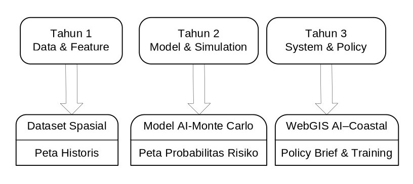
Gambar: Integrasi menuju produk akhir
Visi Produk Akhir:
Sistem akhir akan menjadi prototipe nasional untuk mitigasi erosi berbasis data besar dan kecerdasan buatan, mendukung program Riset dan Inovasi Indonesia Maju (RIIM) serta SDGs 13 & 14 tentang aksi iklim dan perlindungan ekosistem laut.
Komponen Sistem Final
🗺️ WebGIS Dashboard
Platform interaktif untuk visualisasi risiko erosi real-time dengan multi-layer mapping
🤖 ML Prediction Engine
Model ensemble (RF + XGBoost + CNN) untuk prediksi akurat dengan confidence intervals
📊 Monte Carlo Simulator
Kuantifikasi ketidakpastian dan analisis probabilistik untuk multiple scenarios
⚠️ Early Warning System
Sistem peringatan dini dengan notifikasi otomatis untuk zona berisiko tinggi
📱 Mobile Access
Akses mudah melalui web dan mobile untuk stakeholder dan masyarakat
📚 Policy Guidebook
Panduan kebijakan mitigasi berbasis sains untuk pemerintah dan pengelola kawasan
Ringkasan Roadmap 3 Tahun
Foundation Year
Focus: Data Collection & Feature Extraction
Key Activities: Satellite imagery acquisition, preprocessing, baseline mapping, correlation analysis
Deliverables: Comprehensive dataset, baseline erosion maps, Q3 journal publication
Development Year
Focus: ML Model Development & Monte Carlo Integration
Key Activities: ML training (RF, XGBoost, CNN), uncertainty quantification, probabilistic risk mapping
Deliverables: Validated AI-Monte Carlo model, probabilistic risk maps, Q1-Q2 publications
Integration Year
Focus: System Integration & Dissemination
Key Activities: WebGIS development, stakeholder training, policy brief creation
Deliverables: AI-Coastal Risk System (production-ready), policy guidebook, training programs
Research Output